The Ice Age and Origins of the Humber Watershed
Toronto, Ontario
Toronto, Ontario
Introduction
Overview of the
Humber River
Global and Continental Glaciation
Land Form Development in North America
Geological History
of the Great Lakes
Development of the
Oak Ridges Moraine
Geology of the
Humber River Watershed
Ecology
Early Inhabitants
Maps of the
Humber River Watershed
Photo Gallery Humber River Watershed
click image/map to proceed to final chapter on the Humber Watershed
A Elevation Map of The Oak Ridges Terminal Moraine
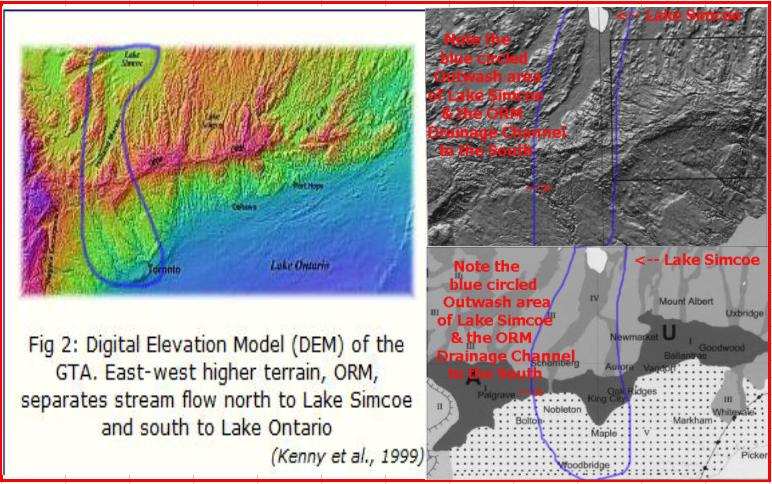
The physiography of Southern Ontario evolved over time as a result of a long sequence of geophysical and geological events culminating in the Pleistocene deposits of the last Ice Age that formed the Oak Ridges Moraine as well as other surficial glacial formations and constructs.
The elevation changes of the surrounding land led to new surface drainage patterns. In many instances the new patterns that developed reflected the heritage of past drainage patterns. The evolution of the Humber watershed reflects the ancestral heritage of the ancient Laurentian drainage channel running from Georgian Bay to Lake Ontario.
Lake Ontario has a present elevation of 75 metres and the height of land of the ORM is close to 525 metres; a difference of 350 metres. The north side of the ORM drains into the ancient Holland River channel while the western third drains south through the low lands ranged along the old Laurentian channel. The moraine to the east is drained by the Don River, Highland Creek & the Rouge River systems among others.
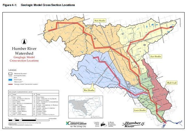
The watershed is now characterized by three (3) branches; West branch, Main branch, and the East branch.
The elevation changes of the surrounding land led to new surface drainage patterns. In many instances the new patterns that developed reflected the heritage of past drainage patterns. The evolution of the Humber watershed reflects the ancestral heritage of the ancient Laurentian drainage channel running from Georgian Bay to Lake Ontario.
Lake Ontario has a present elevation of 75 metres and the height of land of the ORM is close to 525 metres; a difference of 350 metres. The north side of the ORM drains into the ancient Holland River channel while the western third drains south through the low lands ranged along the old Laurentian channel. The moraine to the east is drained by the Don River, Highland Creek & the Rouge River systems among others.
The watershed is now characterized by three (3) branches; West branch, Main branch, and the East branch.